

East Coast Piers Race 2025GPS Tracking for On-the-Water Safety Teams
TractracUK
GPS Tracking for On-the-Water Safety Teams
See Every Boat. Support Every Sailor. Respond Faster.
TracTracUK GPS tracking gives race organisers and safety teams a live, shared picture of everything happening on the water. By tracking competitor boats and safety craft in real time, your safety cover becomes proactive, coordinated, and measurably more effective.
Whether you’re running a small club regatta or a major multi-fleet event, GPS tracking transforms safety from reactive to anticipatory.
-
Every tracked boat appears on a live map, visible to the race team, safety officer, and shore team.
You can instantly see:
Where competitors are relative to the course
Which boats are stopped, capsized, or drifting
The location and movement of all safety boats
No guesswork. No radio-only picture. Just clear, shared situational awareness.
-
GPS data highlights issues before they escalate.
A boat stopped head-to-wind for too long
Sudden loss of speed or erratic movement
A competitor separated from the fleet
Boats drifting towards hazards, shore, or shipping lanes
Safety teams can intervene early, often before a sailor even calls for help.
-
Instead of fixed patrol patterns, safety boats can be dynamically positioned where they are most needed.
Allocate safety boats by fleet density
Move cover as fleets spread or compress
Avoid over-covering one area while leaving gaps elsewhere
Reduce response times by being closer to potential incidents
This is especially valuable for large courses, multiple fleets, and long-distance races.
-
With GPS tracking, everyone is working from the same live picture.
Shore teams can direct safety boats precisely
Race officers can support safety decisions
Safety leads can coordinate multiple craft efficiently
Post-incident reviews are clearer and calmer
This reduces radio traffic, misunderstandings, and stress at critical moments.
-
TracTracUK systems don’t require every boat to carry a tracker to improve safety.
By tracking:
A representative selection of competitors
All safety boats
Key fleets or vulnerable classes
You still gain a highly accurate real-time view of fleet behaviour, density, and risk areas — maximising safety value while keeping costs sensible.
-
The system continuously calculates true GPS distance between boats, safety craft, marks, and shore reference points.
This allows safety teams to:
Identify which safety boat is closest to an incident
Avoid delays caused by incorrect visual assumptions
Monitor separation distances between boats and hazards
Support decisions in reduced visibility or poor conditions
Distance is measured over the water, not guessed by eye or radio description.
-
Safety boats (RIBs) are displayed using dedicated icons that clearly differentiate them from racing boats. This ensures safety craft are instantly recognisable, even in high-density fleet situations.escription
-
Yes. In reduced visibility, busy race areas, or high workload scenarios, GPS tracking provides a shared, objective view of boat positions, supporting confident coordination between shore-based and afloat teams.escription
-
All tracking data is recorded and can be replayed in the Race Viewer. This supports incident review, safety reporting, training, and continuous improvement for future events. description
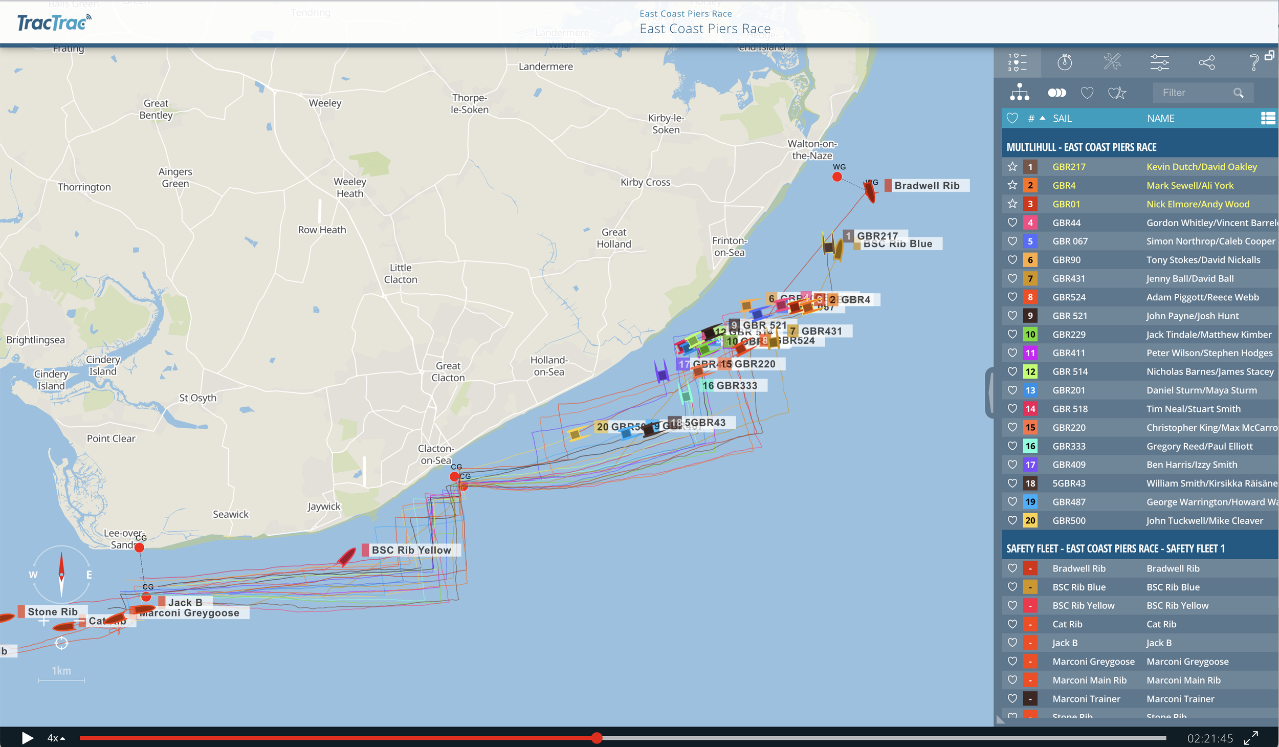
The East Coast Piers Race is the UK's original long-distance race for Catamarans. This is the fast fleet and Safety fleet view in the Race Viewer
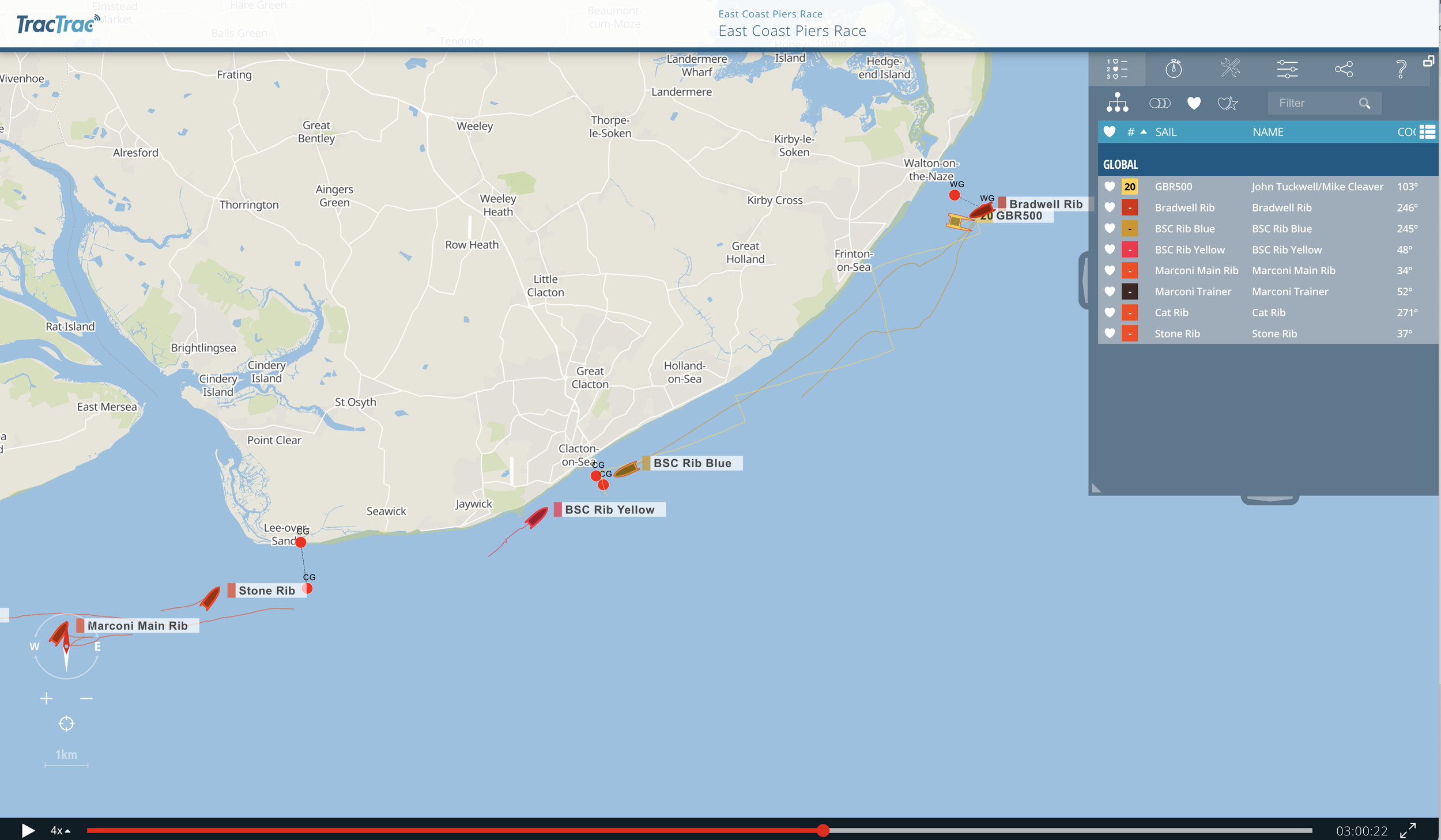
The East Coast Piers Race safety team covered the 42 miles of the race course
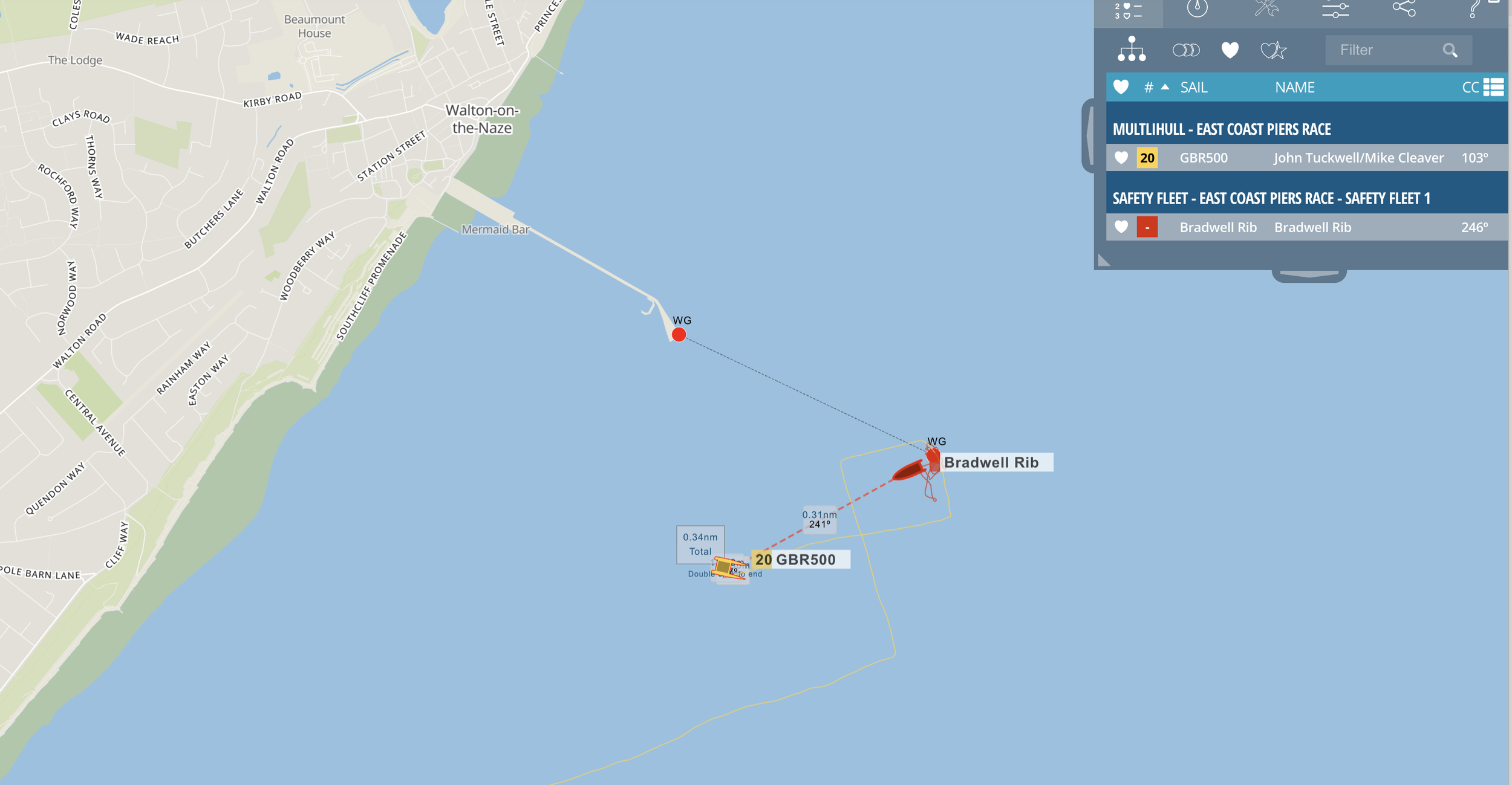
GBR500 was dismasted 2o miles from the start at Marconi SC, from the tracking, we can pinpoint the exact location with distance and compass bearing from Bradwell Safety Rib
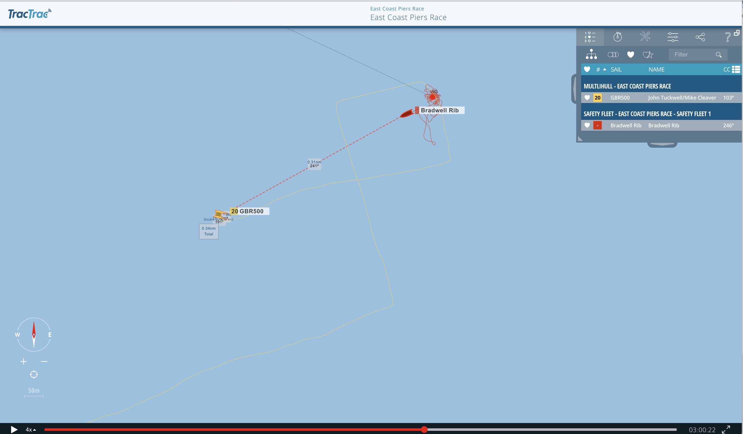
Bearing 241 degrees and .31 NM
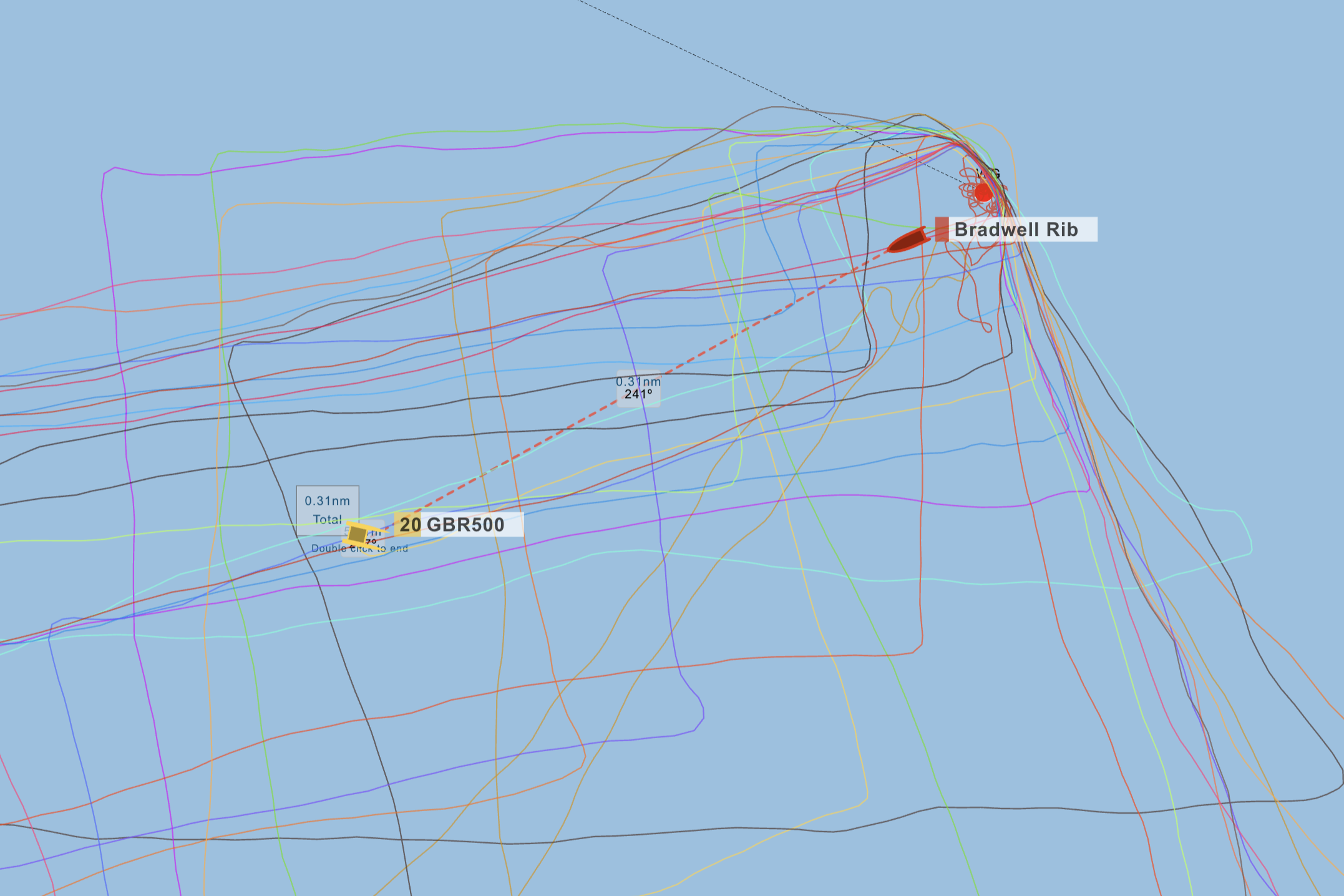
Bradwell Safety rib was contacted and went to assist. The tow home took several hours and was monitored via the tracking